# Measuring Space
## Measuring Space

## Explore this section
[ The Spanish Vara arrow\_circle\_right ](https://measuringdifference.hsites.harvard.edu/space#vara) [ (Beyond) the Vara: Mexican Land Measures over Time arrow\_circle\_right ](https://measuringdifference.hsites.harvard.edu/space#beyond) [ Other Standards: The Meter and More arrow\_circle\_right ](https://measuringdifference.hsites.harvard.edu/space#standards)
#### The Spanish Vara
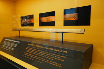
*Photo by Josh Gorman*The Spanish *vara* was a unit of length introduced to the Americas in the colonial period. It eventually became a surveying unit across Mexico, the southwestern US, and vast swaths of Latin America, though its length varied slightly in all of these locations. The vara on display in *Measuring Difference* was seized by an army engineer during the 1847 US invasion of Mexico City. It features multiple sub-units of measurement and the seal of the Mexican Republic.
This object opens *Measuring Difference* because it encapsulates many of the central themes and questions of the exhibit: How are measures created, adapted, and imposed? In what ways do measures include and exclude? And what is the relationship between measurement and power?
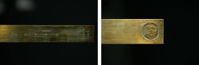
*Photos by Josh Gorman. On loan from National Institute of Standards and Technology.*
#### (Beyond) the Vara: Mexican Land Measures over Time
How can changing representations and measures of land over time help to illustrate the long conceptual transformations of what is today Mexico? The Spanish conquistadors who in the 16th century arrived in Mesoamerica encountered there a vast array of cultural groups, each with their own relationship to space, territory, and measurement. An early illustration of such contact is a late sixteenth-century map of San Pedro Teozacoalco, in present-day Oaxaca, which represents the notable spatial and environmental features of a Mixtec community.
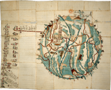
*Map of San Pedro Teozacoalco, 1580. Image Courtesy of the Benson Latin American Collection, University of Texas, Austin.*Of immediate interest in this pictorial manuscript is its iconography, which forefronts Indigenous styles of artistic representation. Pay particular attention to the boundaries of the circular shape. These are place names, represented using glyphs. Note also the depictions of various natural features and boundary markers of the municipality, as well as the detailed dynastic history written on the manuscript’s left side. At the same time, present are multiple signs of European influence. There include horseshoe prints, for example, as well as an array of Christian churches that dot the landscape. The map is painted on sheets of European paper that have been joined to one another at the edges. It emerged from a wave of documentation produced in association with the Relaciones geográficas, which compiled manuscript and artistic portrayals of local geography in response to a questionnaire distributed by the Spanish Crown in the late 1570s. Use of the vara would become commonplace and widespread throughout New Spain. Often overlooked, however, is the enduring role of the vara centuries later, as a state-sanctioned surveying unit in Texas.
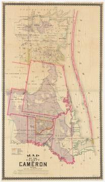
*Map of the county of Cameron, Texas. Image Courtesy of the Harvard Map Collection, Harvard University, G4033.C25G465 1884 .C3.*Following the US annexation of vast southwestern territories following the Mexican-American war, the Spanish vara nonetheless continued to serve as a de facto surveying unit in the former Mexican territories. This 1884 map of Cameron County, Texas, offers one such example. It overlays the boundaries of land grants and zones of land ownership, including the vara in its scale: 1:131,960; or 4,000 varas to the inch. It is attributed to J. J. Cocke, who was the county’s supervisor at the time. In 1919, Texas officially established the vara at 33⅓ inches. Here hand-colored elements again play a prominent role, albeit in a geometrically-ordered spatial representation that prioritizes a definitive representation of land ownership claims in a clearly bounded area. Note, however, that the Gulf of Mexico does not receive a color of its own — in this case, shading is largely reserved for land. Also of note is the combination of multiple measurement units in the map’s scale. What other visual elements serve to distinguish this mode of cartographic representation from that seen in the Map of Teozacoalco?
#### Other Standards: The Meter and More
How about in Europe? Just as in the Americas, for much of the early modern period, complete standardization, at least as we think of it today, was elusive. Measuring Difference includes several examples of wooden and metal rules that reflect an inconsistent metrological landscape across the Atlantic.
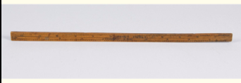
*Wooden Rule With English And Rhenish Feet, Divided Into Digits And Tenths, Owned By Harvard President Edward Holyoke, c. 1720. CHSI #5454.*This wooden rule, for example, from c. 1720, combines both English and Rhenish feet, and is further divided into digits and tenths. It was once owned by former Harvard President Edward Holyoke. The English and Dutch had their own measurement units. The Rhenish foot was replaced by the Napoleonic meter (see below), while the English foot persisted, with occasional modifications, in the UK and US, replacing many traditional units in the process.
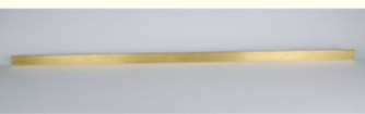
*Brass Meter Standard (France, 1794). CHSI #DW0535*This is a brass standard measure of the meter, from 1794. It represents a key length measure in the metric system, which today is used as either the exclusive or primary system of measurement by about 95% of the world’s population. The meter was invented during the French Revolution to replace previous units. French scientists surveyed for over six years to establish this length.
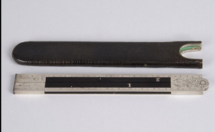
*Folding Foot Rule with Steel Ends (Imperial and Metric Measures, France, 1794). CHSI 1998-1-0003.*New lengths, however, were only as effective as people’s ability to convert between them and other pertinent units of measurement. This folding foot rule with steel ends, also dating from 1794, was used to directly compare imperial and metric units, and as such may have been a transitional device during an important moment in the history of measurement. The old imperial measurement it includes was the pied du roi, or royal foot, which measured 32.48 cm. Though this was related to the English unit, the French foot was slightly longer than its equivalent across the Channel. The broader takeaway, however, is that despite efforts to standardize, vernacular measurements persisted across communities, villages, and regions.
#### Continue
[ Continue to Measuring Nature arrow\_circle\_right ](https://measuringdifference.hsites.harvard.edu/nature)
#### Further Reading
General Audience Resources
- Quave, Kylie E., “The Inka Khipu,” *Smarthistory*, January 20, 2022, .
- Reyes-Martinez, Marcos A., “The Vara: A Standard of Length With a Not-So-Standard History,” *NIST*, October 11, 2019, .
Academic Readings
- Alder, Ken. “A Revolution to Measure: The Political Economy of the Metric System in France.” In *The Values of Precision*, edited by M. Norton Wise, 39–71. Princeton: Princeton University Press, 1995.
- Carmen Jorge, María del, Barbara J. Williams, C. E. Garza-Hume, and Arturo Olvera. “Mathematical Accuracy of Aztec Land Surveys Assessed from Records in the Codex Vergara.” *Proceedings of the National Academy of Sciences* 108, no. 37 (2011): 15053–57. .
- Erbig Jr., Jeffrey Alan. *Where Caciques and Mapmakers Met: Border Making in Eighteenth-Century South America*. Chapel Hill: University of North Carolina Press, 2020.
- Safier, Neil. *Measuring the New World: Enlightenment Science and South America*. Chicago: University of Chicago Press, 2008.